See Also
See Again
© Getty Images
0 / 53 Fotos
Mount Sharp, 2012
- This picture displays the bottom of Mount Sharp, also known as Aeolis Mons, on Mars. The mountain stands at a height of 5.5 km (3.4 miles) above the surrounding valley.
© Reuters
1 / 53 Fotos
Ophir Chasma, 2015
- This image captures a canyon on Mars, specifically in the northern part of the planet's extensive canyon system.
© Reuters
2 / 53 Fotos
Nili Patera, 2014
- Nili Patera, situated atop a lava bed on the grounds of an ancient volcano, stands as one of Mars' most active dune fields.
© Reuters
3 / 53 Fotos
Gullies, 2017
- These flow features, resembling moraines on Earth, are located in the mid-latitudes of Mars. This indicates that the deposits may contain ice or have had ice in the past.
© Reuters
4 / 53 Fotos
Yellowknife Bay, 2013
- These spherical shapes in Yellowknife Bay are believed to be concretions, suggesting that water seeped through sediment pores to create them.
© Reuters
5 / 53 Fotos
Crater, 2014
- An orbiter captured this image of an impact crater on Mars.
© Reuters
6 / 53 Fotos
Link, 2012
- This rock outcrop, known as Link, displays rounded gravel fragments, or clasts, ranging in size up to a few centimeters.
© Reuters
7 / 53 Fotos
Sandy hill, 2014
- These are the sand dunes of Mars' northernmost region, visible as they appear after being covered by seasonal carbon dioxide (dry) ice during winter.
© Reuters
8 / 53 Fotos
Acidalia Plain, 2015
- This plain is depicted as the fictional touchdown location for a crewed mission called Ares 3 in the popular novel and film 'The Martian.'
© Reuters
9 / 53 Fotos
Hellas Planitia, 2011
- The width of the channels in the Hellas Planitia basin varies from 1 to 10 meters (3.3 feet to 33 feet).
© Reuters
10 / 53 Fotos
Noctis Labyrinthus, 2013
- Located on the Tharsis rise in the upper part of Valles Marineris, this area is recognized for its intricate network of deep valleys with steep walls.
© Reuters
11 / 53 Fotos
Gale crater, 2013
- This crater, thought to be around 3.5 to 3.8 billion years old, is likely a dry lake located near the northwestern region of the Aeolis quadrangle.
© Reuters
12 / 53 Fotos
Gale crater, 2013
- The rover designed to explore Gale crater, which is about the size of a car, can be seen as a blue dot in the lower right corner of the image.
© Reuters
13 / 53 Fotos
Gale crater, 2012
- This photo shows a section of the wall of Gale crater, where a system of valleys, thought to be created by water, enters the crater from the surrounding area.
© Reuters
14 / 53 Fotos
Shaler, 2013
- This rock formation's name is Shaler.
© Reuters
15 / 53 Fotos
Trenches, 2008
- The Robotic Arm of the Phoenix lander dug these two trenches.
© Reuters
16 / 53 Fotos
Victoria Crater, 2006
- This impact crater found in the Meridiani Planum plain has a width of approximately 730 meters (2,395 feet)and is named after a ship from Ferdinand Magellan's fleet, the first to sail around the world.
© Reuters
17 / 53 Fotos
Meteorite, 2005
- NASA's Mars Exploration Rover Opportunity took this photo of an iron meteorite on Mars.
© Reuters
18 / 53 Fotos
Columbia Hills, 2004
- This photograph shows the Columbia Hills, a collection of small hills situated in Gusev crater.
© Reuters
19 / 53 Fotos
Water, 2015
- This picture displays narrow streaks approximately 100 meters (328 feet) long that are believed to be created by flowing water.
© Reuters
20 / 53 Fotos
Garni crater, 2015
- These dark, narrow streaks emerging out of the walls of Garni crater are called recurring slope lineae.
© Reuters
21 / 53 Fotos
Round depression, 2015
- NASA's Mars Reconnaissance Orbiter captured this circular depression on the surface of Mars in February 2015.
© Reuters
22 / 53 Fotos
Color Photos, 2008
- This is one of the initial color photographs of the surface of Mars captured after the Phoenix Mars lander spacecraft safely touched down on May 25, 2008. It marked the historic first landing near Mars's northern pole.
© Reuters
23 / 53 Fotos
Mars
- This is the percussion drill located at the tip of the Curiosity Robotic Arm, as it contacts the rock surface on January 27, 2013.
© Reuters
24 / 53 Fotos
Hellas Planitia, 2008
- This image displays a view from a different angle of a mountain located in eastern Hellas Planitia. The mountain harbors sizable glaciers beneath rocks.
© Reuters
25 / 53 Fotos
Hellas Planitia, 2008
- This is an alternative view of the mountain in the eastern Hellas Planitia, which revealed the presence of sizable glaciers concealed beneath fragmented rocks.
© Reuters
26 / 53 Fotos
Mound, 2017
- This mound appears to have blocked the path of dunes as they move south (to the right of this image).
© Reuters
27 / 53 Fotos
Cliff, 2017
- NASA's Mars Reconnaissance Orbiter has captured an intriguing rugged cliff edge in this image.
© Reuters
28 / 53 Fotos
Southern hemisphere, 2017
- Small pits are visible in the bright residual layer of carbon dioxide ice near a larger, circular feature that extends through the ice and dust. This may be an impact crater or a pit created by collapse.
© Reuters
29 / 53 Fotos
Mars, 2016
- The NASA Hubble Space Telescope captured this remarkable image of the Red Planet.
© Reuters
30 / 53 Fotos
Nili Fossae, 2016
- Nili Fossae, situated on the northwest edge of Isidis Planitia crater, is a vibrant area on Mars.
© Reuters
31 / 53 Fotos
Impressive view, 2015
- A plane is visible flying by, while the crescent moon and planets Venus and Mars can be seen close by.
© Reuters
32 / 53 Fotos
Outcrop, 2004
- The Opportunity rover captured an intriguing rock formation in this photograph.
© Reuters
33 / 53 Fotos
Frost, 2015
- This photo taken by NASA's Mars Reconnaissance Orbiter displays frost covering Mars's surface.
© Reuters
34 / 53 Fotos
Rock geology, 2014
- This evenly-layered rock formation displays a pattern typical of a lake-floor sedimentary deposit, suggesting a lake once filled this crater.
© Reuters
35 / 53 Fotos
Cumberland, 2014
- The Curiosity rover bored into a rock nicknamed Cumberland.
© Reuters
36 / 53 Fotos
Mast Camera, 2012
- The Martian landscape serves as the backdrop for the Alpha Particle X-Ray Spectrometer in this image.
© Reuters
37 / 53 Fotos
Cape Verde, 2006
- Cape Verde, a landscape with rocky cliffs, stands on the edge of Victoria crater. These cliffs were named after the country, as a tribute to Ferdinand Magellan who had explored Cape Verde during his round-the-world journey.
© Reuters
38 / 53 Fotos
Bathurst Inlet, 2012
- This marks the highest point of Bathurst Inlet, a rock situated on the surface of Aeolis Palus within the Gale crater.
© Reuters
39 / 53 Fotos
Newton crater, 2011
- These water flows are observed during the spring and summer on a slope within the Newton crater.
© Reuters
40 / 53 Fotos
Sheepbed, 2013
- This is a rock formation found at the Sheepbed, a deposit of mudstone located in the Yellowknife Bay region within Gale crater.
© Reuters
41 / 53 Fotos
Marquette Island, 2010
- Marquette Island is a rock about the size of a basketball whose texture and composition suggest it came from deep inside the Martian crust.
© Reuters
42 / 53 Fotos
Becquerel crater, 2008
- The pattern in this sedimentary bedrock within Becquerel crater suggests rhythmic bedding.
© Reuters
43 / 53 Fotos
Phoenix, 2008
- The descent of NASA's Phoenix lander to the Martian surface with the attached parachute is visible.
© Reuters
44 / 53 Fotos
Valles Marineris, 2006
- Valles Marineris serves as Mars's counterpart to the Grand Canyon.
© Getty Images
45 / 53 Fotos
Reull Vallis, 2004
- The Reull Vallis was likely formed by water. The valley got its name from the Gaelic word for planet.
© Getty Images
46 / 53 Fotos
Echus Chasma, 2008
- This aerial photograph displays the Echus Chasma, which is among the largest water source regions on Mars.
© Getty Images
47 / 53 Fotos
Sleepy Hollow, 2004
- This circular topographic view, known as Sleepy Hollow, was discovered in the Gusev Crater on Mars.
© Getty Images
48 / 53 Fotos
Mars Pathfinder, 1997
- This photo depicts NASA's Mars Pathfinder probe surveying the planet's landscape in 1997.
© Getty Images
49 / 53 Fotos
Echus Chasma, 2008
- Waterfalls may have cascaded down these towering cliffs in the past, which stand at a staggering 4,000 meters (13,123 feet). The remarkably even valley floor indicates that it was subsequently submerged by basaltic lava.
© Getty Images
50 / 53 Fotos
Phoenix, 2008
- This image depicts the Phoenix lander arriving on the Red Planet, as envisioned by an artist.
© Getty Images
51 / 53 Fotos
Mars, 1997
- This high-definition image captures the detailed features of Mars, while it was positioned approximately 100 million km (60 million miles) away from Earth. See also: Space tourism: would you try it?
© Getty Images
52 / 53 Fotos
© Getty Images
0 / 53 Fotos
Mount Sharp, 2012
- This picture displays the bottom of Mount Sharp, also known as Aeolis Mons, on Mars. The mountain stands at a height of 5.5 km (3.4 miles) above the surrounding valley.
© Reuters
1 / 53 Fotos
Ophir Chasma, 2015
- This image captures a canyon on Mars, specifically in the northern part of the planet's extensive canyon system.
© Reuters
2 / 53 Fotos
Nili Patera, 2014
- Nili Patera, situated atop a lava bed on the grounds of an ancient volcano, stands as one of Mars' most active dune fields.
© Reuters
3 / 53 Fotos
Gullies, 2017
- These flow features, resembling moraines on Earth, are located in the mid-latitudes of Mars. This indicates that the deposits may contain ice or have had ice in the past.
© Reuters
4 / 53 Fotos
Yellowknife Bay, 2013
- These spherical shapes in Yellowknife Bay are believed to be concretions, suggesting that water seeped through sediment pores to create them.
© Reuters
5 / 53 Fotos
Crater, 2014
- An orbiter captured this image of an impact crater on Mars.
© Reuters
6 / 53 Fotos
Link, 2012
- This rock outcrop, known as Link, displays rounded gravel fragments, or clasts, ranging in size up to a few centimeters.
© Reuters
7 / 53 Fotos
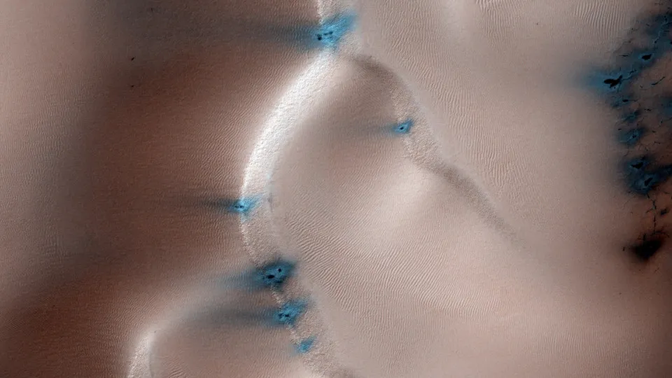
Sandy hill, 2014
- These are the sand dunes of Mars' northernmost region, visible as they appear after being covered by seasonal carbon dioxide (dry) ice during winter.
© Reuters
8 / 53 Fotos
Acidalia Plain, 2015
- This plain is depicted as the fictional touchdown location for a crewed mission called Ares 3 in the popular novel and film 'The Martian.'
© Reuters
9 / 53 Fotos
Hellas Planitia, 2011
- The width of the channels in the Hellas Planitia basin varies from 1 to 10 meters (3.3 feet to 33 feet).
© Reuters
10 / 53 Fotos
Noctis Labyrinthus, 2013
- Located on the Tharsis rise in the upper part of Valles Marineris, this area is recognized for its intricate network of deep valleys with steep walls.
© Reuters
11 / 53 Fotos
Gale crater, 2013
- This crater, thought to be around 3.5 to 3.8 billion years old, is likely a dry lake located near the northwestern region of the Aeolis quadrangle.
© Reuters
12 / 53 Fotos
Gale crater, 2013
- The rover designed to explore Gale crater, which is about the size of a car, can be seen as a blue dot in the lower right corner of the image.
© Reuters
13 / 53 Fotos
Gale crater, 2012
- This photo shows a section of the wall of Gale crater, where a system of valleys, thought to be created by water, enters the crater from the surrounding area.
© Reuters
14 / 53 Fotos
Shaler, 2013
- This rock formation's name is Shaler.
© Reuters
15 / 53 Fotos
Trenches, 2008
- The Robotic Arm of the Phoenix lander dug these two trenches.
© Reuters
16 / 53 Fotos
Victoria Crater, 2006
- This impact crater found in the Meridiani Planum plain has a width of approximately 730 meters (2,395 feet)and is named after a ship from Ferdinand Magellan's fleet, the first to sail around the world.
© Reuters
17 / 53 Fotos
Meteorite, 2005
- NASA's Mars Exploration Rover Opportunity took this photo of an iron meteorite on Mars.
© Reuters
18 / 53 Fotos
Columbia Hills, 2004
- This photograph shows the Columbia Hills, a collection of small hills situated in Gusev crater.
© Reuters
19 / 53 Fotos
Water, 2015
- This picture displays narrow streaks approximately 100 meters (328 feet) long that are believed to be created by flowing water.
© Reuters
20 / 53 Fotos
Garni crater, 2015
- These dark, narrow streaks emerging out of the walls of Garni crater are called recurring slope lineae.
© Reuters
21 / 53 Fotos
Round depression, 2015
- NASA's Mars Reconnaissance Orbiter captured this circular depression on the surface of Mars in February 2015.
© Reuters
22 / 53 Fotos
Color Photos, 2008
- This is one of the initial color photographs of the surface of Mars captured after the Phoenix Mars lander spacecraft safely touched down on May 25, 2008. It marked the historic first landing near Mars's northern pole.
© Reuters
23 / 53 Fotos
Mars
- This is the percussion drill located at the tip of the Curiosity Robotic Arm, as it contacts the rock surface on January 27, 2013.
© Reuters
24 / 53 Fotos
Hellas Planitia, 2008
- This image displays a view from a different angle of a mountain located in eastern Hellas Planitia. The mountain harbors sizable glaciers beneath rocks.
© Reuters
25 / 53 Fotos
Hellas Planitia, 2008
- This is an alternative view of the mountain in the eastern Hellas Planitia, which revealed the presence of sizable glaciers concealed beneath fragmented rocks.
© Reuters
26 / 53 Fotos
Mound, 2017
- This mound appears to have blocked the path of dunes as they move south (to the right of this image).
© Reuters
27 / 53 Fotos
Cliff, 2017
- NASA's Mars Reconnaissance Orbiter has captured an intriguing rugged cliff edge in this image.
© Reuters
28 / 53 Fotos
Southern hemisphere, 2017
- Small pits are visible in the bright residual layer of carbon dioxide ice near a larger, circular feature that extends through the ice and dust. This may be an impact crater or a pit created by collapse.
© Reuters
29 / 53 Fotos
Mars, 2016
- The NASA Hubble Space Telescope captured this remarkable image of the Red Planet.
© Reuters
30 / 53 Fotos
Nili Fossae, 2016
- Nili Fossae, situated on the northwest edge of Isidis Planitia crater, is a vibrant area on Mars.
© Reuters
31 / 53 Fotos
Impressive view, 2015
- A plane is visible flying by, while the crescent moon and planets Venus and Mars can be seen close by.
© Reuters
32 / 53 Fotos
Outcrop, 2004
- The Opportunity rover captured an intriguing rock formation in this photograph.
© Reuters
33 / 53 Fotos
Frost, 2015
- This photo taken by NASA's Mars Reconnaissance Orbiter displays frost covering Mars's surface.
© Reuters
34 / 53 Fotos
Rock geology, 2014
- This evenly-layered rock formation displays a pattern typical of a lake-floor sedimentary deposit, suggesting a lake once filled this crater.
© Reuters
35 / 53 Fotos
Cumberland, 2014
- The Curiosity rover bored into a rock nicknamed Cumberland.
© Reuters
36 / 53 Fotos
Mast Camera, 2012
- The Martian landscape serves as the backdrop for the Alpha Particle X-Ray Spectrometer in this image.
© Reuters
37 / 53 Fotos
Cape Verde, 2006
- Cape Verde, a landscape with rocky cliffs, stands on the edge of Victoria crater. These cliffs were named after the country, as a tribute to Ferdinand Magellan who had explored Cape Verde during his round-the-world journey.
© Reuters
38 / 53 Fotos
Bathurst Inlet, 2012
- This marks the highest point of Bathurst Inlet, a rock situated on the surface of Aeolis Palus within the Gale crater.
© Reuters
39 / 53 Fotos
Newton crater, 2011
- These water flows are observed during the spring and summer on a slope within the Newton crater.
© Reuters
40 / 53 Fotos
Sheepbed, 2013
- This is a rock formation found at the Sheepbed, a deposit of mudstone located in the Yellowknife Bay region within Gale crater.
© Reuters
41 / 53 Fotos
Marquette Island, 2010
- Marquette Island is a rock about the size of a basketball whose texture and composition suggest it came from deep inside the Martian crust.
© Reuters
42 / 53 Fotos
Becquerel crater, 2008
- The pattern in this sedimentary bedrock within Becquerel crater suggests rhythmic bedding.
© Reuters
43 / 53 Fotos
Phoenix, 2008
- The descent of NASA's Phoenix lander to the Martian surface with the attached parachute is visible.
© Reuters
44 / 53 Fotos
Valles Marineris, 2006
- Valles Marineris serves as Mars's counterpart to the Grand Canyon.
© Getty Images
45 / 53 Fotos
Reull Vallis, 2004
- The Reull Vallis was likely formed by water. The valley got its name from the Gaelic word for planet.
© Getty Images
46 / 53 Fotos
Echus Chasma, 2008
- This aerial photograph displays the Echus Chasma, which is among the largest water source regions on Mars.
© Getty Images
47 / 53 Fotos
Sleepy Hollow, 2004
- This circular topographic view, known as Sleepy Hollow, was discovered in the Gusev Crater on Mars.
© Getty Images
48 / 53 Fotos
Mars Pathfinder, 1997
- This photo depicts NASA's Mars Pathfinder probe surveying the planet's landscape in 1997.
© Getty Images
49 / 53 Fotos
Echus Chasma, 2008
- Waterfalls may have cascaded down these towering cliffs in the past, which stand at a staggering 4,000 meters (13,123 feet). The remarkably even valley floor indicates that it was subsequently submerged by basaltic lava.
© Getty Images
50 / 53 Fotos
Phoenix, 2008
- This image depicts the Phoenix lander arriving on the Red Planet, as envisioned by an artist.
© Getty Images
51 / 53 Fotos
Mars, 1997
- This high-definition image captures the detailed features of Mars, while it was positioned approximately 100 million km (60 million miles) away from Earth. See also: Space tourism: would you try it?
© Getty Images
52 / 53 Fotos
Mesmerizing photos of Mars that will make you want to move there
The lovely vistas of our celestial neighbor
© Getty Images
Explore the beautiful landscapes of our neighboring planet by browsing through this gallery of breathtaking images. Click through to get started.
RECOMMENDED FOR YOU


MOST READ
- Last Hour
- Last Day
- Last Week