


See Also
See Again
© Getty Images
0 / 30 Fotos
Climate background
- Earth's weather and climate are shaped by a complex interplay of factors, from our solar system's influence to atmospheric dynamics and seasonal cycles.
© Shutterstock
1 / 30 Fotos
Opposite forces
- Adding to the complexity, every few years, Earth undergoes El Niño and La Niña events, two contrasting phases of the El Niño Southern Oscillation (ENSO) cycle.
© Getty Images
2 / 30 Fotos
Fluctuating temperatures
- Periods of average conditions are referred to as "ENSO-Neutral." However, fluctuations in wind and ocean temperatures can trigger El Niño or La Niña events.
© Getty Images
3 / 30 Fotos
How long do they last?
- These cycles typically last between two and seven years, with individual El Niño and La Niña events lasting nine to 12 months, though they can persist for several years.
© Getty Images
4 / 30 Fotos
What causes these events?
- Earth's spherical shape causes uneven solar heating. The Equator, directly facing the Sun, receives more intense sunlight than the poles, which are angled away.
© Shutterstock
5 / 30 Fotos
Shaping weather conditions
- Like steam rises from a boiling pot, the direct sunlight at the Equator warms the air and moisture, causing it to rise into the atmosphere. As this warm, moist air ascends, it cools and condenses, forming clouds and contributing to the lush rainforests located in the area.
© Getty Images
6 / 30 Fotos
Continuous cycle
- Warm air continues to rise at the Equator, pushing cooler air towards the poles. This cooler air then sinks and flows back towards the Equator, completing the Hadley Cell cycle.
© Getty Images
7 / 30 Fotos
Winds influence
- Earth's rotation deflects surface winds created by Hadley Cells toward the Equator, a phenomenon known as the Coriolis Effect. This effect forms the trade winds on either side of the Equator, and changes in these winds signal the onset of El Niño and La Niña events.
© Shutterstock
8 / 30 Fotos
Air pressure
- ENSO's impact on Earth's climate is ancient, evident in paleoclimate records. While documented since the 1500s, its mechanisms were only understood in the 20th century when a study of the Indian monsoons led to the discovery of the Southern Oscillation. This recurring seesaw pattern of air pressure across the tropical Pacific Ocean is a key component of ENSO.
© Getty Images
9 / 30 Fotos
Air circulation
- Unlike Hadley Cells, which circulate air North and South, this oscillation—known as Walker Circulation—moves air East and West across the equatorial Pacific. Driven by trade winds and ocean temperature, this circulation pattern plays a crucial role in shaping global weather patterns.
© Getty Images
10 / 30 Fotos
El Niño vs. La Niña
- Every few years, fluctuations in Pacific Ocean temperatures and trade winds signal a shift in the Walker Circulation. These shifts, known as El Niño and La Niña events, can disrupt global weather patterns and ecosystems. But what happens during each of these events?
© Shutterstock
11 / 30 Fotos
El Niño
- El Niño, the warm phase of ENSO, features warmer-than-average Pacific Ocean temperatures. This disrupts normal weather patterns, leading to droughts in Asia and intense storms in the Americas. Atmospheric rivers, long, narrow bands of moisture in the sky, can bring heavy rain and flooding to coastal regions.
© Getty Images
12 / 30 Fotos
El Niño
- El Niño's effects vary regionally, often reversing normal weather patterns. Areas like East Asia and the Amazon, typically wet, experience drought during El Niño. Conversely, usually dry regions like Western North America can see significant rainfall.
© Getty Images
13 / 30 Fotos
End of El Niño 2024
- After months of record-high ocean temperatures, devastating coral reefs, intense drought in the Amazon, and extreme North American rainfall, one of the strongest El Niño events on record ended in June 2024.
© Getty Images
14 / 30 Fotos
La Niña arrives
- With La Niña here, how will global and local weather patterns be affected? As the opposite extreme of El Niño, La Niña brings its own set of weather changes, varying by region.
© Getty Images
15 / 30 Fotos
Sea temperatures
- La Niña is characterized by strong trade winds and cooler-than-average Pacific Ocean temperatures. Unlike El Niño, which reverses normal conditions, La Niña typically intensifies neutral conditions in most parts of the world, with a few exceptions.
© Getty Images
16 / 30 Fotos
Strong winds
- La Niña strengthens the East-to-West trade winds, pushing warm surface waters westward and allowing cold, nutrient-rich water to rise to the surface in the eastern Pacific.
© Getty Images
17 / 30 Fotos
North American effects
- While La Niña typically brings colder, wetter winters to northern North America and warmer, drier winters to the south, the National Oceanic and Atmospheric Administration (NOAA) predicts a 40-50% chance of above-average temperatures for New York State this winter (December-February).
© Getty Images
18 / 30 Fotos
Hurricane activity
- La Niña weakens wind shear, a natural barrier to hurricane formation. This could lead to a more active Atlantic hurricane season, especially for regions like Florida. The 2020 and 2021 hurricane seasons, both occurring during La Niña years, were particularly active.
© Getty Images
19 / 30 Fotos
Hurricane activity
- The record-breaking warm sea surface temperatures in the tropical Atlantic further contribute to specialists' concerns about a potentially severe hurricane season.
© Getty Images
20 / 30 Fotos
Southern Hemisphere impact
- For East Asia and Australia, La Niña often brings increased rainfall. Australia experienced severe flooding during the last La Niña event. The Indian monsoon is also favored during La Niña, leading to above-average rainfall. However, these effects may take a few months to manifest, especially in South Asia.
© Getty Images
21 / 30 Fotos
Africa impact
- Except for some western African regions that may experience increased rainfall, La Niña tends to exacerbate droughts in eastern Africa. Recent La Niña events have led to devastating droughts in the region, particularly in 2022, where the March-May rainfall was the lowest on record.
© Getty Images
22 / 30 Fotos
Europe impact
- While the connection between ENSO and Europe is less direct due to distance, La Niña is expected to bring cooler temperatures to central and western Europe this winter. Additionally, reduced precipitation is forecast for the mainland, with increased rainfall in the North and South.
© Getty Images
23 / 30 Fotos
Getting ready
- As we transition from El Niño to a potentially intense La Niña phase in 2025, many regions, especially in North America, will face significant challenges. Industries like agriculture, energy, and disaster management, heavily reliant on stable weather patterns, will need to adapt to the shifting climate conditions.
© Getty Images
24 / 30 Fotos
Agriculture
- Farmers must closely monitor changing precipitation patterns as the shift from El Niño to La Niña can significantly impact growing conditions. Regions that experienced wet conditions in 2024 may face drought-like conditions if La Niña returns in late 2025.
© Getty Images
25 / 30 Fotos
Energy
- Energy companies must prepare for increased heating demands during colder La Niña winters. Additionally, drought conditions in certain regions can impact hydroelectric and renewable energy generation, potentially leading to power outages.
© Getty Images
26 / 30 Fotos
Disaster management
- Given the increased risk of hurricanes and other extreme conditions during La Niña, 2025 could be a challenging year for disaster preparedness. Governments and communities must remain vigilant and ready to respond to potential disasters.
© Getty Images
27 / 30 Fotos
La Niña and climate change
- While the exact impact of global warming on the ENSO cycle remains uncertain, scientists predict it will likely be amplified. Recent history shows El Niño and La Niña events becoming stronger and more frequent, leading to more extreme weather like droughts, floods, heatwaves, wildfires, and severe storms.
© Getty Images
28 / 30 Fotos
La Niña and climate change
- The recent 2020-2023 La Niña event demonstrates how global warming is amplifying ENSO's effects. Record-breaking global temperatures since summer 2023, primarily driven by record-breaking ocean warmth, and the 2024 breach of the 1.5°C global warming threshold raise concerns about the potential impact of the upcoming La Niña event. Sources: (Astrum) (The Economic Times) (University of Colorado Arts and Sciences Magazine) (Advancing Earth and Space Sciences Journal) (Hydrorain) See also: Watch out for these nature warnings before a natural disaster
© Getty Images
29 / 30 Fotos
© Getty Images
0 / 30 Fotos
Climate background
- Earth's weather and climate are shaped by a complex interplay of factors, from our solar system's influence to atmospheric dynamics and seasonal cycles.
© Shutterstock
1 / 30 Fotos
Opposite forces
- Adding to the complexity, every few years, Earth undergoes El Niño and La Niña events, two contrasting phases of the El Niño Southern Oscillation (ENSO) cycle.
© Getty Images
2 / 30 Fotos
Fluctuating temperatures
- Periods of average conditions are referred to as "ENSO-Neutral." However, fluctuations in wind and ocean temperatures can trigger El Niño or La Niña events.
© Getty Images
3 / 30 Fotos
How long do they last?
- These cycles typically last between two and seven years, with individual El Niño and La Niña events lasting nine to 12 months, though they can persist for several years.
© Getty Images
4 / 30 Fotos
What causes these events?
- Earth's spherical shape causes uneven solar heating. The Equator, directly facing the Sun, receives more intense sunlight than the poles, which are angled away.
© Shutterstock
5 / 30 Fotos
Shaping weather conditions
- Like steam rises from a boiling pot, the direct sunlight at the Equator warms the air and moisture, causing it to rise into the atmosphere. As this warm, moist air ascends, it cools and condenses, forming clouds and contributing to the lush rainforests located in the area.
© Getty Images
6 / 30 Fotos
Continuous cycle
- Warm air continues to rise at the Equator, pushing cooler air towards the poles. This cooler air then sinks and flows back towards the Equator, completing the Hadley Cell cycle.
© Getty Images
7 / 30 Fotos
Winds influence
- Earth's rotation deflects surface winds created by Hadley Cells toward the Equator, a phenomenon known as the Coriolis Effect. This effect forms the trade winds on either side of the Equator, and changes in these winds signal the onset of El Niño and La Niña events.
© Shutterstock
8 / 30 Fotos
Air pressure
- ENSO's impact on Earth's climate is ancient, evident in paleoclimate records. While documented since the 1500s, its mechanisms were only understood in the 20th century when a study of the Indian monsoons led to the discovery of the Southern Oscillation. This recurring seesaw pattern of air pressure across the tropical Pacific Ocean is a key component of ENSO.
© Getty Images
9 / 30 Fotos
Air circulation
- Unlike Hadley Cells, which circulate air North and South, this oscillation—known as Walker Circulation—moves air East and West across the equatorial Pacific. Driven by trade winds and ocean temperature, this circulation pattern plays a crucial role in shaping global weather patterns.
© Getty Images
10 / 30 Fotos
El Niño vs. La Niña
- Every few years, fluctuations in Pacific Ocean temperatures and trade winds signal a shift in the Walker Circulation. These shifts, known as El Niño and La Niña events, can disrupt global weather patterns and ecosystems. But what happens during each of these events?
© Shutterstock
11 / 30 Fotos
El Niño
- El Niño, the warm phase of ENSO, features warmer-than-average Pacific Ocean temperatures. This disrupts normal weather patterns, leading to droughts in Asia and intense storms in the Americas. Atmospheric rivers, long, narrow bands of moisture in the sky, can bring heavy rain and flooding to coastal regions.
© Getty Images
12 / 30 Fotos
El Niño
- El Niño's effects vary regionally, often reversing normal weather patterns. Areas like East Asia and the Amazon, typically wet, experience drought during El Niño. Conversely, usually dry regions like Western North America can see significant rainfall.
© Getty Images
13 / 30 Fotos
End of El Niño 2024
- After months of record-high ocean temperatures, devastating coral reefs, intense drought in the Amazon, and extreme North American rainfall, one of the strongest El Niño events on record ended in June 2024.
© Getty Images
14 / 30 Fotos
La Niña arrives
- With La Niña here, how will global and local weather patterns be affected? As the opposite extreme of El Niño, La Niña brings its own set of weather changes, varying by region.
© Getty Images
15 / 30 Fotos
Sea temperatures
- La Niña is characterized by strong trade winds and cooler-than-average Pacific Ocean temperatures. Unlike El Niño, which reverses normal conditions, La Niña typically intensifies neutral conditions in most parts of the world, with a few exceptions.
© Getty Images
16 / 30 Fotos
Strong winds
- La Niña strengthens the East-to-West trade winds, pushing warm surface waters westward and allowing cold, nutrient-rich water to rise to the surface in the eastern Pacific.
© Getty Images
17 / 30 Fotos
North American effects
- While La Niña typically brings colder, wetter winters to northern North America and warmer, drier winters to the south, the National Oceanic and Atmospheric Administration (NOAA) predicts a 40-50% chance of above-average temperatures for New York State this winter (December-February).
© Getty Images
18 / 30 Fotos
Hurricane activity
- La Niña weakens wind shear, a natural barrier to hurricane formation. This could lead to a more active Atlantic hurricane season, especially for regions like Florida. The 2020 and 2021 hurricane seasons, both occurring during La Niña years, were particularly active.
© Getty Images
19 / 30 Fotos
Hurricane activity
- The record-breaking warm sea surface temperatures in the tropical Atlantic further contribute to specialists' concerns about a potentially severe hurricane season.
© Getty Images
20 / 30 Fotos
Southern Hemisphere impact
- For East Asia and Australia, La Niña often brings increased rainfall. Australia experienced severe flooding during the last La Niña event. The Indian monsoon is also favored during La Niña, leading to above-average rainfall. However, these effects may take a few months to manifest, especially in South Asia.
© Getty Images
21 / 30 Fotos
Africa impact
- Except for some western African regions that may experience increased rainfall, La Niña tends to exacerbate droughts in eastern Africa. Recent La Niña events have led to devastating droughts in the region, particularly in 2022, where the March-May rainfall was the lowest on record.
© Getty Images
22 / 30 Fotos
Europe impact
- While the connection between ENSO and Europe is less direct due to distance, La Niña is expected to bring cooler temperatures to central and western Europe this winter. Additionally, reduced precipitation is forecast for the mainland, with increased rainfall in the North and South.
© Getty Images
23 / 30 Fotos
Getting ready
- As we transition from El Niño to a potentially intense La Niña phase in 2025, many regions, especially in North America, will face significant challenges. Industries like agriculture, energy, and disaster management, heavily reliant on stable weather patterns, will need to adapt to the shifting climate conditions.
© Getty Images
24 / 30 Fotos
Agriculture
- Farmers must closely monitor changing precipitation patterns as the shift from El Niño to La Niña can significantly impact growing conditions. Regions that experienced wet conditions in 2024 may face drought-like conditions if La Niña returns in late 2025.
© Getty Images
25 / 30 Fotos
Energy
- Energy companies must prepare for increased heating demands during colder La Niña winters. Additionally, drought conditions in certain regions can impact hydroelectric and renewable energy generation, potentially leading to power outages.
© Getty Images
26 / 30 Fotos
Disaster management
- Given the increased risk of hurricanes and other extreme conditions during La Niña, 2025 could be a challenging year for disaster preparedness. Governments and communities must remain vigilant and ready to respond to potential disasters.
© Getty Images
27 / 30 Fotos
La Niña and climate change
- While the exact impact of global warming on the ENSO cycle remains uncertain, scientists predict it will likely be amplified. Recent history shows El Niño and La Niña events becoming stronger and more frequent, leading to more extreme weather like droughts, floods, heatwaves, wildfires, and severe storms.
© Getty Images
28 / 30 Fotos
La Niña and climate change
- The recent 2020-2023 La Niña event demonstrates how global warming is amplifying ENSO's effects. Record-breaking global temperatures since summer 2023, primarily driven by record-breaking ocean warmth, and the 2024 breach of the 1.5°C global warming threshold raise concerns about the potential impact of the upcoming La Niña event. Sources: (Astrum) (The Economic Times) (University of Colorado Arts and Sciences Magazine) (Advancing Earth and Space Sciences Journal) (Hydrorain) See also: Watch out for these nature warnings before a natural disaster
© Getty Images
29 / 30 Fotos
La Niña is here and weather patterns are set to change
Winter in the US shows early signs of La Niña’s influence
© Getty Images
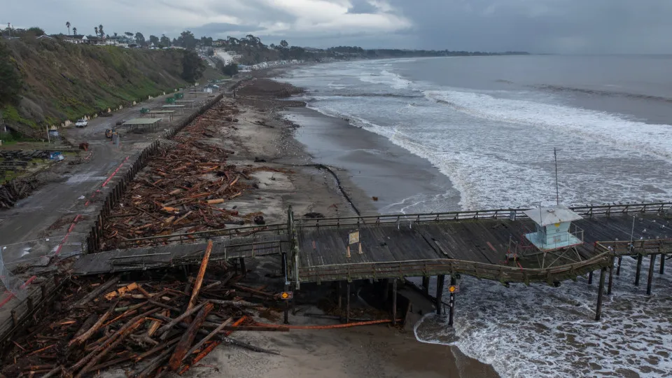
The world witnessed a year marked by extreme weather events in 2024, from devastating hurricanes to catastrophic floods. Now as we settle into 2025, the looming threat of La Niña adds another layer of uncertainty to the global climate picture.
This winter, La Niña has arrived later than expected but has already started influencing weather patterns. This prominent climate phenomenon is known for significantly shaping winter weather, particularly in the United States. By shifting the jet stream, it alters key weather dynamics, leading to cooler temperatures across regions from Alaska to the northern Plains, while areas such as the desert southwest and southeast experience warmer, drier conditions. Beyond North America, La Niña’s impact is also felt globally, especially near the western Pacific Ocean in the Northern Hemisphere, where meteorologists predict an intensification of rainfall and storms through March.
Meteorologists closely track both La Niña and El Niño because they influence global weather patterns, often leading to extreme weather events such as droughts, floods, and hurricanes. Curious to understand the potential impacts of La Niña globally and in your area? Click through this gallery to find out more.
RECOMMENDED FOR YOU


MOST READ
- Last Hour
- Last Day
- Last Week